|
Links to related sites ...
|
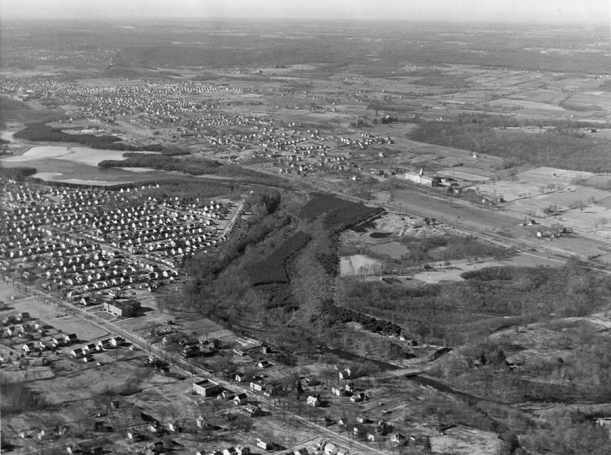
Hamden High School - 1949
Hamden High School opened for the 1935-36 school year, providing a secondary school education for Hamden students. Previously, the town paid a $100 annual tuition for each Hamden student to attend New Haven's Hillhouse High School on Tower Parkway.
Groundbreaking for the new school took place on October 12, 1934 on a 24-acre site known as the Humiston Farm. Dedication took place a year later, on October 28, 1935. Herbert Landry was the school's first principal, overseeing 46 faculty members and 1,200 students.
|
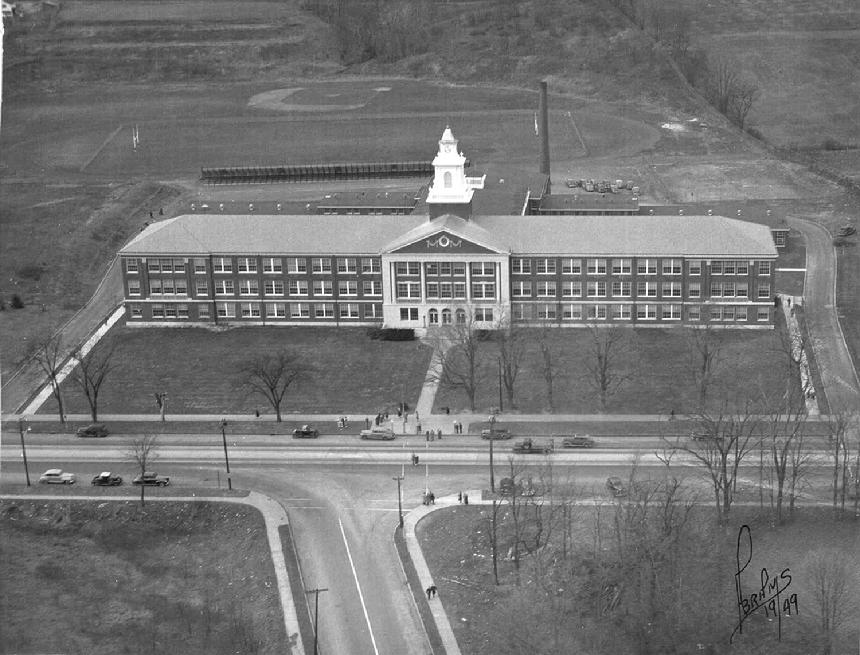 |
| * Abrams Photo (c. 1949) |
|
|
According to a 1985 Hamden Chronicle article commemorating the school's 50th anniversary, the new school had "52 classrooms; an auditorium with nearly 1200 seating capacity; 16 offices; cafeterias; four gymnasiums with shower rooms; completely equipped shops, home economics facilities, and science laboratories."
Connolly Parkway, which meets Dixwell Avenue opposite the high school, was completed in 1940 to make travel to and from the high school much easier for the students who lived in the Spring Glen and State Street areas.
This Abrams photo, dated 1949, was probably taken the same day as the aerial view of Centerville that is featured elsewhere on this website.
Posted 6/19/2019
|
_______________________________________________________________________________________________________
|
Whitneyville, 1937 - Repaving Whitney Avenue
Bus service replaced trolleys on the New Haven to Waterbury route in 1937, when Whitney Avenue was repaved in concrete, and trolley tracks were either removed or paved over.
This photo from the John DellaVechhia collection at the Hamden Historical Society shows two unidentified Hamden police officers taking care of business on Whitney just north of the Putnam Avenue intersection. The Tudor style building in the background is 1240 Whitney Avenue. In 1937 it housed the Larsen Real Estate Co. and the Great American Atlantic & Pacific (A&P) Tea Company. The building is still around.
Posted 6/10/2019
|
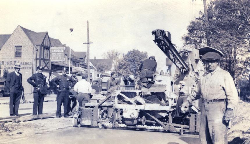 |
| * Whitneyville, 1937 |
|
|
Repaving Whitney Avenue Bus service replaced trolleys on the New Haven to Waterbury route in 1937, when Whitney Avenue was repaved in concrete, and trolley tracks were either removed or paved over. This photo from the John DellaVechhia collection at the Hamden Historical Society shows two unidentified Hamden police officers taking care of business on Whitney just north of the Putnam Avenue intersection. The Tudor style building in the background is 1240 Whitney Avenue. In 1937 it housed the Larsen Real Estate Co. and the Great American Atlantic & Pacific (A&P) Tea Company. The building is still around.
|
This is what 1240 Whitney Avenue looks like today. Still a commercial building, but the "Tudor" look is gone.
(Government Solutions Photo)
|
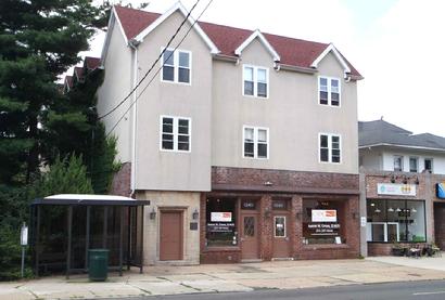 |
| * 1240 Whitney Avenue looks like today. |
|
|
_______________________________________________________________________________________________________
|
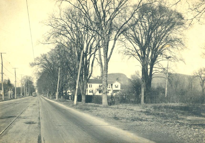 |
| * c. 1930 - Whitney Avenue looking north at St. Mary's Cemetery |
|
|
Mount Carmel c. 1930
Mount Carmel was still quite rural at the start of the 1930s. This view of Whitney Avenue looking north shows the stone pillars at the entrance to St. Mary's Cemetery on the far left. The head of the Giant is clearly visible at the right. That white building is still around, now a law office just south of Sisk Brothers Funeral Home. The Waterbury trolley is heading south on Whitney. The trolley tracks along Whitney Avenue would disappear in 1937 when the road was re-paved. The Dixwell Avenue and State Street tracks remained for more than another decade. Trolleys throughout the greater New Haven area were all gone as of September 26, 1948.
Posted 6/7/2019
|
_______________________________________________________________________________________________________
|
 |
| * Aerial view of the Augerville-Spring Glen section as taken from the North Haven side of Whitney Avenue |
|
|
A treat for Hamden aficionados
This 1938 aerial photo of Whitney Avenue was taken from the North Haven side, looking southwest. Spring Glen School on the west side of Whitney Avenue in the lower left quadrant. Hamden High School is seen in its pre-parkway setting, just to the right in the center of the photo, with the Peters' orchards just north of the three year old building.
Skiff Street is a barely two-land thoroughfare, with the bridge over Mill River the most significant landmark. The little village found in the Skiff and Whitney neighborhood was once known as "Augerville." Augerville Schoolhouse No. 6, which closed in the late 19-teens, was located on the north side Skiff Street between Whitney Avenue and Mill River. The building is visible in this photo.
Everything east of Whitney Avenue in lower part the photo, of course, is North Haven. Whitney Avenue separates the two towns from the Mill River on the north end to Short Hill Road on the south end.
|
_______________________________________________________________________________________________________
|
|