How the Wilbur Cross Parkway Affected Hamden Streets
by Paul Saubestre
|
|
The portion of the Wilbur Cross Parkway from Exit 59, at Whalley Avenue in New Haven, to Exit 61, at Whitney Avenue in Hamden, was the last portion of the statewide parkway system to be completed, not opening to the public until 1949. Doubtless this was because of the difficult choice the state had to make of how the road should cross West Rock Ridge.
.
A route west of the ridge, crossing into Hamden around West Shepard Avenue, was considered. Had this route been taken, it would have greatly affected how Hamden developed in the following decades. But this route would have taken the parkway too far away from the center of New Haven.
.
Going east of the ridge would have disrupted too much developed area in New Haven. Going over the ridge would have required extensive cutting and filling for a managable grade, ruining West Rock Park. So the best alternative was to construct the West Rock (now Heroes) Tunnel.
.
The Wilbur Cross had only been constructed from the Housatonic River to Route 34 in Orange when the start of World War II brought it to a stop. But the state continued to acquire land for its right-of-way during the war. It had little difficulty for the first couple of miles past the tunnel in Hamden, as the area consisted almost entirely of farmland.
.
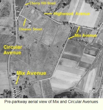
But as the route approached Dixwell Avenue, there would be significant disruption of the area, as can be seen in the three images below, all covering about the same area. The first is an aerial photo from 1934, the second a 1927 street map, and finally a current street map.
|
 |
| Pre-parkway aerial view |
|
|
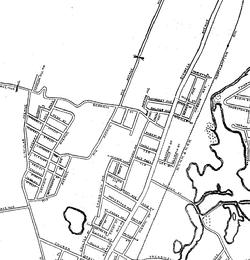 |
| 1927 Street Map |
|
|
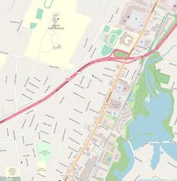 |
| Whitney Avenue Today |
|
|
CLICK ON THE IMAGE TO ENLARGE IT
| CLICK ON THE IMAGE TO ENLARGE IT
| CLICK ON THE IMAGE TO ENLARGE IT
|
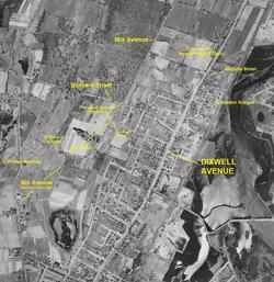
The most significant disruption was to Mix Avenue, which originally began at Circular Avenue. The parkway would sever its southernmost half mile from the northern straight section extending to Shepard Avenue. The 1951 city directory was the first to list it in two parts, Circular to Roosevelt and Benham to Shepard. This seems to have caused enough confusion that, during Hamden's 1950-51 fiscal year, the southern part was renamed Battis Road, in honor of Frederick Battis, a Hamden High School graduate who had died in World War II.
.
Numbering of houses on Mix began at Circular. After the division, the few houses on the northern portion retained their original numbers. The lowest numbered house on Mix Avenue in 1953 was number 465. This same number is on its southernmost condominium complex today.
.
A close look at the 1934 aerial view in the area west of the southern portion of Mix reveals how the parkway caused more changes to streets. Faint lines are visible where streets had already been cleared and graded through the farm fields. On the northwest side of the parkway, Eleanor Street and Highwood Avenue had to be truncated, terminated at the newly constructed Vantage Road paralleling the parkway. On the southeast side, Arents Road was built to parallel the parkway, and three streets, Ashley, Fremont, and Fenwick, were completely eliminated. For some reason not directly caused by the parkway, the portions of Springdale and Federal streets west of Cherry Hill Road, and the L-shaped Elmwood Place between Springdale and Cherry Hill, were never built. They are still shown as paper streets – owned by the Town, but not improved – on the tax assessor map.
|
There were some more changes east of Dixwell. The aerial photo shows how Hobson Avenue extended all the way to Marietta Street. There is also, not well cleared, a parallel street to its west, named Merritt Avenue on the 1927 map, renamed Victor Street perhaps to avoid confusion with Merritt Street in the East Side. The parkway caused Marietta, Hobson, and Victor to all become dead ends.
|
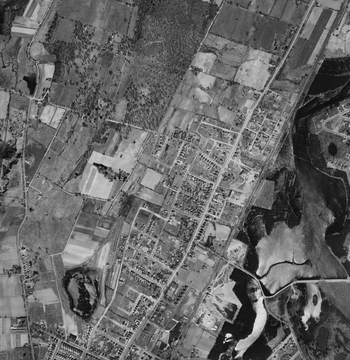
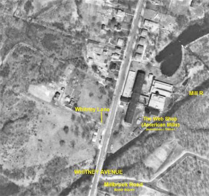
One other street that was wiped out of existence by the pakway was Whitney Lane, a dead-end street extending west from Whitney Avenue north of its crossing of Mill River (see 1934 aerial photo below).
.
Whitney Lane was last listed in the 1939 city directory. A comparison of the 1934 aerial photo and current map of the same area (below) shows that Whitney Lane was where the looping southbound Exit 61 ramp is now.
|
 |
| Pre-parkway aerial view of Whitney Avenue |
|
|
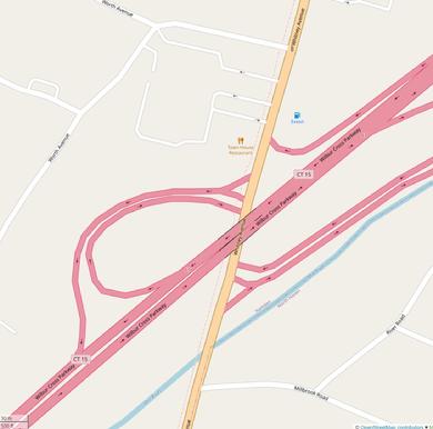 |
| Parkway crossing Whitney Avenue today |
|
|
CLICK ON THE IMAGE TO ENLARGE IT
| CLICK ON THE IMAGE TO ENLARGE IT
|
|
.
.
1927 street map of Hamden by Price & Lee Co. Copy in Hamden Historical Society History Room.
.
New Haven city directories at Ancestry Library Edition. Free access with a Hamden library card at hamdenlibrary.org
.
.
.
|
|